CitySurf offers a set of display and analysis tools to meet strategic necessities of defense and intelligence industry. Citysurf can perform query, analyze, edit/create and display operations on spatial data from wide variety of origins in a 3D platform.
Users can manage virtually limitless amount of data in easy to use and fast CitySurf environment. Robust CitySurf framework provides functions for collection, production, archiving, dissemination and publishing information about earth. Ability to perform analyzes on spatial data is critical for mission success since mission planning, logistics and C2I all have common spatial relationships. Users can integrate defense data with relevant spatial data and conduct a battle field planning ,even analyze digital terrains.
Citysurf Defense and Intelligence solutions offer ;
Capability to manage unlimited amount of data.
Client – Server architecture.Fast and easy analysis of terrain elevation and slope.
Ability to display vector data (shp, tab, Oracle SDO, Postgis ) quickly and easily.
Shadow analysis with dynamic light position.
Visibility analysis of defined circular area with given angle ( 0º → 360º ).
Real time 3D path profile with visibility analysis.
Interactive creation capabilities for great circles and rhumb lines.
Ability to build custom applications with ActiveX SDK.
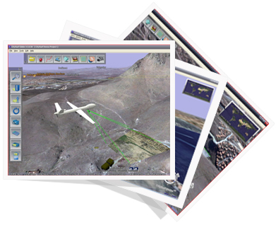
Projected live video feed on terrain ( for aircraft, uav and city security projects ).
Color- coded DTED and contour lines.
Ability to define areas of interest.
Ability to create line, polygon and point objects to server side.
Geocoding supportNetwork analysis.
Spatial query support.
Database driven state borders, political borders, city locations, buildings and poi.
Custom target coordinates and known threat ranges.
Ability to define different authorization levels for different user groups
Client profile of CitySurf 3D Military and Intelligence Solutions ;